Enrique

Tropicial cyclone archives of the 2009 eastern and central Pacific hurricane season
Post Reply
User avatar
Tropical Inspector
Site Admin
Site Admin
Posts: 3697
Joined: Tue Feb 20, 2007 2:28 pm
Antispam: no
Location: Under a palm tree
Contact:

Enrique

Post by Tropical Inspector »

Monday Night Update

Enrique forming - not a threat to Mexico

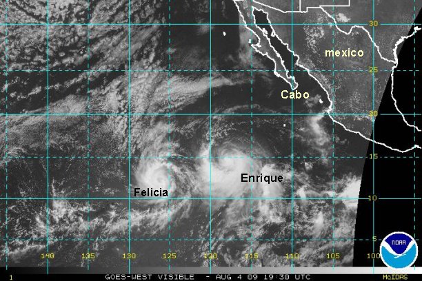
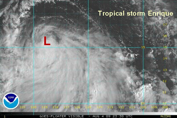
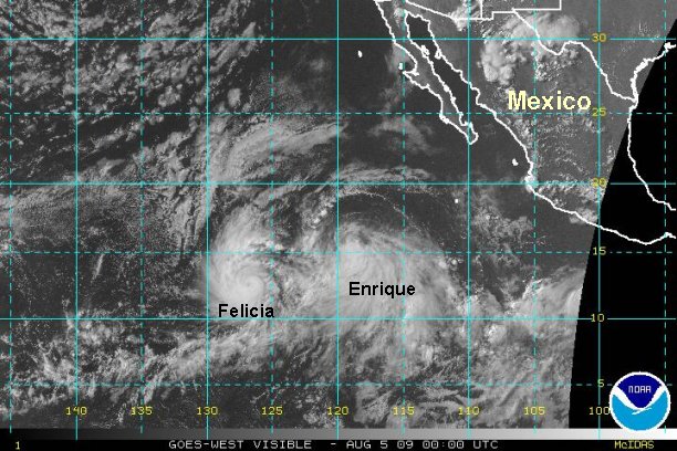
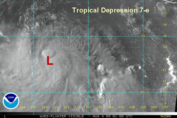
Tropical depression 7-e was officially classified earlier this afternoon. As of 9:30 pm edt / 6:30 pm pdt it was centered near 13.0° N / 113.7° W or about 720 miles south southwest of Cabo San Lucas, Mexico.

Deep convection has increased and we believe that tropical depression 7-e is now tropical storm Enrique. NHC will probably classify this system soon. We estimate top sustained winds at 40 mph.

This tropical cyclone is moving west northwest at about 15 mph. Conditions are favorable for futher strengthening as it moves out to sea away from Mexico.

*****nhc just classified system tropical storm Enrique at 8 pm edt....40 mph

Tropicast: Pacific Floater Visible Satellite
Image
Rich Johnson
Twitter: https://twitter.com/richjohnsonwx
Certified Broadcast Meteorologist - Hurricane Expert
User avatar
Tropical Inspector
Site Admin
Site Admin
Posts: 3697
Joined: Tue Feb 20, 2007 2:28 pm
Antispam: no
Location: Under a palm tree
Contact:

Re: Tropical storm Enrique

Post by Tropical Inspector »

Tuesday Morning Update

Enrique slowly strengthening

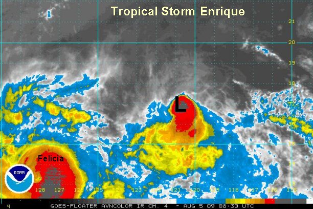
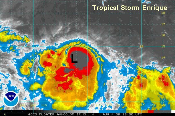
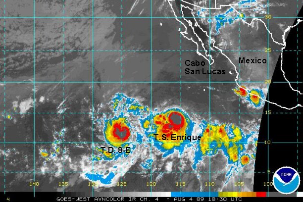
Tropical storm Enrique was continues to develop and move far away from Mexico. Outflow is being hampered on the northern side of the circulation, possibly from the outflow of tropical depression 7-E (Felicia) from the west. As of 6:30 am edt / 3:30 am pdt it was centered near 13.8° N / 116.2° W or about 740 miles south southwest of Cabo San Lucas, Mexico. Once again, excellent center estimates are difficult during the night with I.R. imagery.

We estimate top sustained winds at 45 mph and increasing with the deep burst of convection currently underway.

It is moving west northwest at about 15 mph. Conditions are favorable for futher strengthening as it moves out to sea away from Mexico.


Tropicast: Pacific Floater I.R. Satellite
Image


Tropicast: Eastern Pacific I.R. Satellite
Image
Rich Johnson
Twitter: https://twitter.com/richjohnsonwx
Certified Broadcast Meteorologist - Hurricane Expert
User avatar
Tropical Inspector
Site Admin
Site Admin
Posts: 3697
Joined: Tue Feb 20, 2007 2:28 pm
Antispam: no
Location: Under a palm tree
Contact:

Re: Tropical storm Enrique

Post by Tropical Inspector »

NHC increased Enrique to 60 mph. On our earlier update we estimated 45 mph and increasing. We agree with this assessment as outflow and organization look impressive on visible satellite. Enrique may come close to hurricane strength in the next 24 hours before reaching cooler water.
Rich Johnson
Twitter: https://twitter.com/richjohnsonwx
Certified Broadcast Meteorologist - Hurricane Expert
User avatar
Tropical Inspector
Site Admin
Site Admin
Posts: 3697
Joined: Tue Feb 20, 2007 2:28 pm
Antispam: no
Location: Under a palm tree
Contact:

Re: Tropical storm Enrique

Post by Tropical Inspector »

Tuesday Afternoon Update

Enrique weakens some, fighting shear

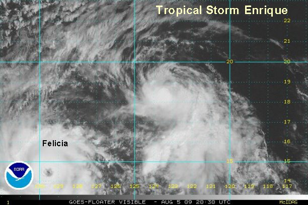
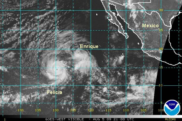
Tropical storm Enrique appears to be fighting some shear on the north side of the circulation probably enhanced by Felicia to the west. There also appears to be some dry air that has wrapped into the circulation. As of 3:30 pm edt / 12:30 pm pdt it was centered near 14.6° N / 117.8° W or about 760 miles south southwest of Cabo San Lucas, Mexico.

We estimate top sustained winds at 50 mph and possibly a little weaker. It is moving west northwest at about 13 mph.

Enrique may go through some weakening and strengthening phases with shear in the next 24 hours. It is interesting to note the forecast models wind speed in which they have Enrique stronger than Felicia. That certainly isn't the case at this time.

Tropicast: Pacific Floater Visible Satellite
Image


Tropicast: Eastern Pacific Visible Satellite
Image
Rich Johnson
Twitter: https://twitter.com/richjohnsonwx
Certified Broadcast Meteorologist - Hurricane Expert
User avatar
Tropical Inspector
Site Admin
Site Admin
Posts: 3697
Joined: Tue Feb 20, 2007 2:28 pm
Antispam: no
Location: Under a palm tree
Contact:

Re: Tropical storm Enrique

Post by Tropical Inspector »

NHC left the wind speed still up at 60 mph on their last advisory. We'll stick with 50 mph.
Rich Johnson
Twitter: https://twitter.com/richjohnsonwx
Certified Broadcast Meteorologist - Hurricane Expert
User avatar
Tropical Inspector
Site Admin
Site Admin
Posts: 3697
Joined: Tue Feb 20, 2007 2:28 pm
Antispam: no
Location: Under a palm tree
Contact:

Re: Tropical storm Enrique

Post by Tropical Inspector »

Tuesday Night Update

Enrique continues to fight shear

Tropical storm Enrique is still fighting shear. Convection near the center looks weak, but still very organized and is increasing on the southern half of the circulation. As of 8:30 pm edt / 5:30 pm pdt Enrique was centered near 15.3° N / 119.0° W or about 780 miles southwest of Cabo San Lucas, Mexico.

We estimate top sustained winds at 60 mph. It is moving west northwest at about 13 mph.

Enrique may go through some weakening and strengthening phases with shear in the next 24 hours.

Tropicast: Pacific Floater Visible Satellite
Image


Tropicast: Eastern Pacific Visible Satellite
Image
Rich Johnson
Twitter: https://twitter.com/richjohnsonwx
Certified Broadcast Meteorologist - Hurricane Expert
User avatar
Tropical Inspector
Site Admin
Site Admin
Posts: 3697
Joined: Tue Feb 20, 2007 2:28 pm
Antispam: no
Location: Under a palm tree
Contact:

Re: Tropical storm Enrique

Post by Tropical Inspector »

Wednesday Morning Update

Enrique slightly weaker

As of 5:00 am edt / 2:00 am pdt Enrique was centered near 16.8° N / 120.8° W or about 825 miles west southwest of Cabo San Lucas, Mexico.

We estimate top sustained winds at 50 mph or slightly weaker. This is in agreement with NHC.

It is moving west northwest at about 15 mph.

Wind shear enhanced by the proximity of hurricane Felicia will continue to hamper development on tropical storm Enrique. The northern side of the circulation continues to struggle as northerly shear keeps convection near to and south of the circulation center.

Tropicast: Pacific Floater I.R. Satellite
Image


Tropicast: Eastern Pacific I.R. Satellite
Image
Rich Johnson
Twitter: https://twitter.com/richjohnsonwx
Certified Broadcast Meteorologist - Hurricane Expert
User avatar
Tropical Inspector
Site Admin
Site Admin
Posts: 3697
Joined: Tue Feb 20, 2007 2:28 pm
Antispam: no
Location: Under a palm tree
Contact:

Re: Tropical storm Enrique

Post by Tropical Inspector »

Wednesday Evening Update

Enrique unchanged

As of 5:30 pm edt / 2:30 pm pdt Enrique was centered near 18.4° N / 123.5° W or about 925 miles west southwest of Cabo San Lucas, Mexico.

We estimate top sustained winds at 50 mph. This is in agreement with NHC.

It is moving west northwest at about 13 mph.

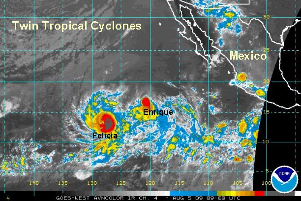
Tropical storm Enrique is still moving northwest and is not being absorbed by Felicia. The two tropical cyclones are close enough for a Fujiwhara effect. The main effect to Enrique has been wind shear from Felicia weakening its strength. Both systems have had some directional effects also.

Enrique will not be a concern to Mexico or Hawaii.

Tropicast: Pacific Floater Visible Satellite
Image


Tropicast: Eastern Pacific Visible Satellite
Image
Rich Johnson
Twitter: https://twitter.com/richjohnsonwx
Certified Broadcast Meteorologist - Hurricane Expert
User avatar
Tropical Inspector
Site Admin
Site Admin
Posts: 3697
Joined: Tue Feb 20, 2007 2:28 pm
Antispam: no
Location: Under a palm tree
Contact:

Re: Enrique

Post by Tropical Inspector »

Thursday Morning Update

Enrique holding on

As of 7:00 am edt / 4:00 am pdt Enrique was centered near 20.7° N / 126.7° W or about 1080 miles west southwest of Cabo San Lucas, Mexico.

We estimate top sustained winds at 50 mph. This is in agreement with NHC.

It is moving west northwest at about 17 mph.

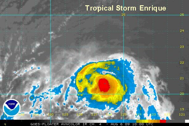
Tropical storm Enrique has not changed much at all in appearance for the past 24 hours. Despite Hurricane Felicia in fairly close proximity and the wind shear that its battling, Enrique has not lost its convection nor is any closer to being absorbed.

Enrique will not be a concern to Mexico or Hawaii.

Tropicast: Pacific Floater I.R. Satellite
Image
Rich Johnson
Twitter: https://twitter.com/richjohnsonwx
Certified Broadcast Meteorologist - Hurricane Expert
User avatar
Tropical Inspector
Site Admin
Site Admin
Posts: 3697
Joined: Tue Feb 20, 2007 2:28 pm
Antispam: no
Location: Under a palm tree
Contact:

Re: Enrique

Post by Tropical Inspector »

Thursday Afternoon Update

Enrique slowly weakening

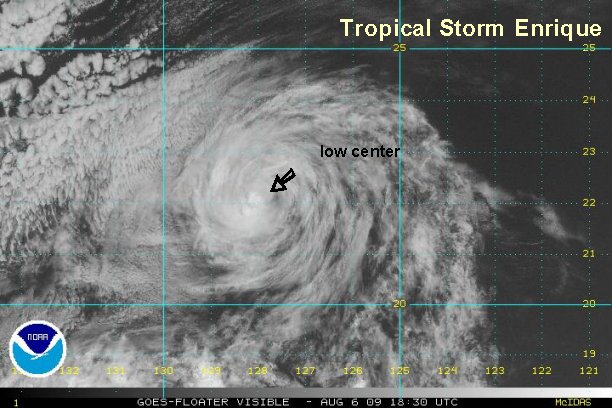
As of 3:00 pm edt / 12:00 pm pdt Enrique was centered near 22.2° N / 128.0°, W or about 1150 miles west of Cabo San Lucas, Mexico / 1750 miles east northeast of the Big Island of Hawaii.

We estimate top sustained winds at 40 mph. It is moving west northwest at about 17 mph.

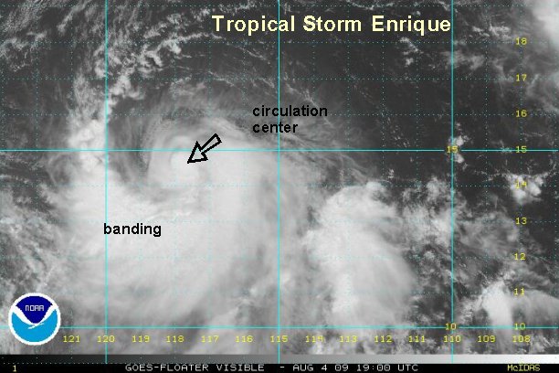
Wind shear is slowly taking its toll on tropical storm Enrique today. It is a minimal tropical storm and will likely become a tropical depression by this evening or tonight. It is holding onto a small area of convection on the south side of its circulation.

Enrique will not be a concern to Mexico or Hawaii.

Tropicast: Pacific Floater Visible Satellite
Image
Rich Johnson
Twitter: https://twitter.com/richjohnsonwx
Certified Broadcast Meteorologist - Hurricane Expert
User avatar
Tropical Inspector
Site Admin
Site Admin
Posts: 3697
Joined: Tue Feb 20, 2007 2:28 pm
Antispam: no
Location: Under a palm tree
Contact:

Re: Enrique

Post by Tropical Inspector »

Enrique was declared a depression on the last advisory. This will be our last update on this system.
Rich Johnson
Twitter: https://twitter.com/richjohnsonwx
Certified Broadcast Meteorologist - Hurricane Expert
Post Reply

Return to “2009 Eastern / Central Pacific Hurricane Season Archives”

Who is online

Users browsing this forum: No registered users and 0 guests