Wednesday Evening Update
Tropical depression forming well southwest of Cabo
In our estimation, the tropical disturbance is now a tropical depression centered about 915 miles southwest of Cabo San Lucas, moving northwest at about 10 mph. If organization continues, this system will be classified as tropical storm Andres tomorrow sometime. This feature is not a threat to land. An upper air trough is west of the disturbance with stronger westerly just north. There is a window of opportunity for some development before entering a more hostile wind environment.
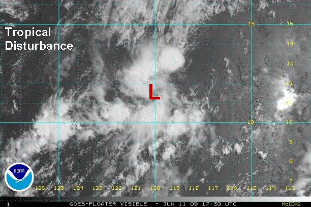
Tropicast: Pacific Floater Visible Satellite
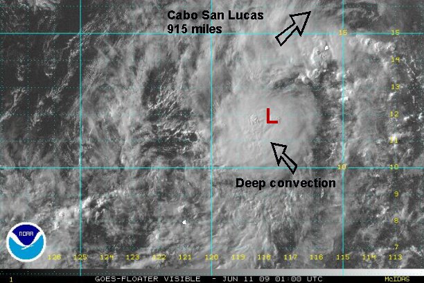
Visible satellite imagery indicates that a surface low has formed and has moved under a deep, growing burst of convection.
Tropical disturbance - June 10-12
- Tropical Inspector
- Site Admin
- Posts: 3629
- Joined: Tue Feb 20, 2007 2:28 pm
- Antispam: no
- Location: Under a palm tree
- Contact:
Tropical disturbance - June 10-12
Rich Johnson
Twitter: https://twitter.com/richjohnsonwx
Certified Broadcast Meteorologist - Hurricane Expert
Twitter: https://twitter.com/richjohnsonwx
Certified Broadcast Meteorologist - Hurricane Expert
- Tropical Inspector
- Site Admin
- Posts: 3629
- Joined: Tue Feb 20, 2007 2:28 pm
- Antispam: no
- Location: Under a palm tree
- Contact:
Re: Tropical depression forming
Thursday Morning Update
Tropical low moving west, away from Mexico
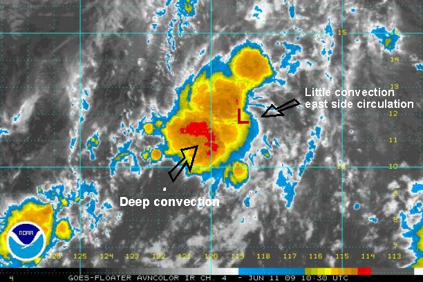
As of 7 am edt ( 4 am pdt ), the low is centered 960 miles southwest of Cabo San Lucas. Although a bit tough to tell with I.R. satellite imagery, it appears that the low is now moving west or just north of west. We believe that this system is still currently a tropical depression. It is undergoing some easterly shear and the low center may be exposed if this continues. If the low is exposed, this system may have had lost its chance to be classified.
Tropicast: Pacific Floater I.R. Satellite
The deep convection near the center of circulation has held together overnight and has grown somewhat. The surface low appears to be closer to the eastern edge of convection, indicating some shear.
Rich Johnson
Twitter: https://twitter.com/richjohnsonwx
Certified Broadcast Meteorologist - Hurricane Expert
Twitter: https://twitter.com/richjohnsonwx
Certified Broadcast Meteorologist - Hurricane Expert
- Tropical Inspector
- Site Admin
- Posts: 3629
- Joined: Tue Feb 20, 2007 2:28 pm
- Antispam: no
- Location: Under a palm tree
- Contact:
Re: Tropical depression forming
NHC just upgraded their outlook to high chance for development.....They are waiting to see the first visible satellite images or next Quickscat image.
Rich Johnson
Twitter: https://twitter.com/richjohnsonwx
Certified Broadcast Meteorologist - Hurricane Expert
Twitter: https://twitter.com/richjohnsonwx
Certified Broadcast Meteorologist - Hurricane Expert
- Tropical Inspector
- Site Admin
- Posts: 3629
- Joined: Tue Feb 20, 2007 2:28 pm
- Antispam: no
- Location: Under a palm tree
- Contact:
Re: Tropical depression forming
Thursday Afternoon Update
Tropical low moving west southwest, away from Mexico
As of 2:30 pm edt ( 11:30 am pdt ), the tropical disturbance is centered near 11.4 N / 120.0 W or about 1040 miles southwest of Cabo San Lucas. it is now moving west southwest at about 12 mph. NHC did not upgrade to a depression after looking at the visible imagery, but still has this area in a high chance of development. It appears still that there is enough of a structure to classify this system as a tropical depression. It will not be a threat to land.
Tropicast: Pacific Floater Visible Satellite
Some convection is still near the weak low center, although not close to the magnitude of last night. The more impressive convection is to the northeast and southwest of the circulation.
Rich Johnson
Twitter: https://twitter.com/richjohnsonwx
Certified Broadcast Meteorologist - Hurricane Expert
Twitter: https://twitter.com/richjohnsonwx
Certified Broadcast Meteorologist - Hurricane Expert
- Tropical Inspector
- Site Admin
- Posts: 3629
- Joined: Tue Feb 20, 2007 2:28 pm
- Antispam: no
- Location: Under a palm tree
- Contact:
Re: Tropical depression forming
Thursday Evening Update
Tropical disturbance becoming weaker
The tropical disturbance is approximately 900 miles southwest of Cabo San Lucas, moving north northwest. Satellite imagery has displayed a very complex structure late this afternoon, indicating a weakening phase. The low will be heading into a more hostile environment for development soon.
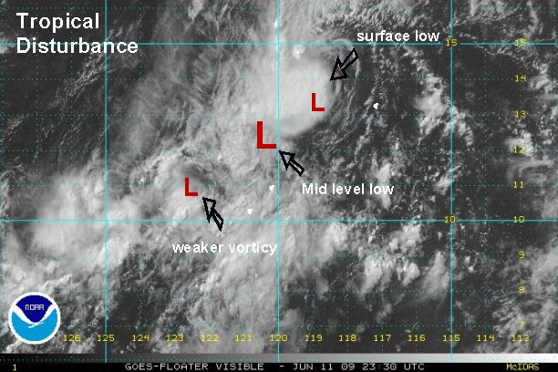
Tropicast: Pacific Floater Visible Satellite
Visible satellite imagery shows the main circulation in the center of the convection is only in the mid levels. A surface low is to the northeast of the mid level circulation. That surface low is on the edge of a convective burst. Third, another weaker surface vorticy is southwest of the mid level circulation.
Rich Johnson
Twitter: https://twitter.com/richjohnsonwx
Certified Broadcast Meteorologist - Hurricane Expert
Twitter: https://twitter.com/richjohnsonwx
Certified Broadcast Meteorologist - Hurricane Expert
- Tropical Inspector
- Site Admin
- Posts: 3629
- Joined: Tue Feb 20, 2007 2:28 pm
- Antispam: no
- Location: Under a palm tree
- Contact:
Re: Tropical disturbance - June 10-12
Friday Morning Update
Tropical disturbance dissipating
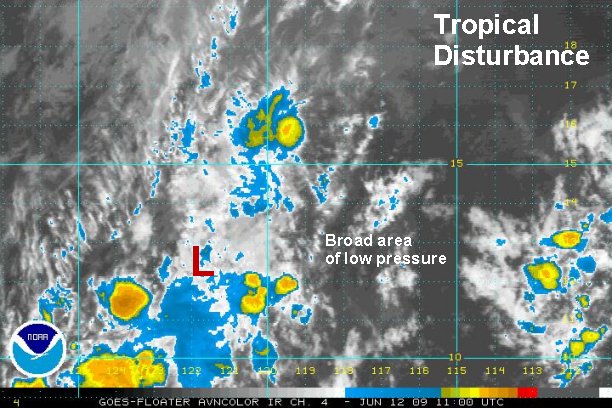
The tropical disturbance has continued its weakening phase over night and is now just a broad area of low pressure with a few smaller vorticies embedded. This will be the last update on this system.
Tropicast: Pacific Floater I.R. Satellite
Satellite shows a decrease in convection and disorganization. The "L: marks center of circulation, which appears to be a mid level low.
Rich Johnson
Twitter: https://twitter.com/richjohnsonwx
Certified Broadcast Meteorologist - Hurricane Expert
Twitter: https://twitter.com/richjohnsonwx
Certified Broadcast Meteorologist - Hurricane Expert
Who is online
Users browsing this forum: No registered users and 0 guests