Polo

Tropicial cyclone archives of the 2008 eastern and central Pacific hurricane season
Post Reply
User avatar
Tropical Inspector
Site Admin
Site Admin
Posts: 3652
Joined: Tue Feb 20, 2007 2:28 pm
Antispam: no
Location: Under a palm tree
Contact:

Polo

Post by Tropical Inspector »

Sunday Afternoon Update
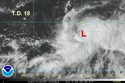
18-E forms

We have been following this disturbance for a couple of days now. It looked like it had reached tropical depression status about 24 hours ago. NHC has now officially upgraded it to a depression at 35 mph and is forecast to become a tropical storm. It is so well formed at this point that we think not only is it a storm, but is probably about 50 mph.

(Polo) is centered at 8.8 N / 109.8 W or about 970 miles south of Cabo San Lucas. It is moving wnw at about 16 mph. It is no threat to Mexico. There is potential that it could strengthen to a strong tropical storm before facing wind shear.


TropicalWeather.net's Tropical Pic
Image
Rich Johnson
Twitter: https://twitter.com/richjohnsonwx
Certified Broadcast Meteorologist - Hurricane Expert
User avatar
Tropical Inspector
Site Admin
Site Admin
Posts: 3652
Joined: Tue Feb 20, 2007 2:28 pm
Antispam: no
Location: Under a palm tree
Contact:

Post by Tropical Inspector »

Monday Early AM Mini Update
Polo a minimal tropical storm

The tropical depression was upgraded a short while ago as expected. The I.R. satellite imagery showed that there was a small burst of deep convection a few hours ago. The clouds tops now have warmed again. The official strength is 40 mph by NHC. We will estimate 45 mph, down from 50 mph earlier.

Polo is no threat to Mexico.
Rich Johnson
Twitter: https://twitter.com/richjohnsonwx
Certified Broadcast Meteorologist - Hurricane Expert
User avatar
Tropical Inspector
Site Admin
Site Admin
Posts: 3652
Joined: Tue Feb 20, 2007 2:28 pm
Antispam: no
Location: Under a palm tree
Contact:

Post by Tropical Inspector »

Monday Late Morning Update
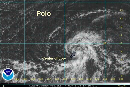
Polo remains a small tropical storm

There really has been little change since last night's update. Tropical storm Polo is continuing a little north of due west. It is about 1000 miles ssw of Cabo San Lucas. Officially Polo is at 40 mph. Our estimate is 40-45 mph, so little difference than NHC's thinking. We still think it looked the strongest about 24 hours ago. There is potential for some strengthening before Polo encounters a less favorable environment.


TropicalWeather.net's Tropical Pic
Image
Rich Johnson
Twitter: https://twitter.com/richjohnsonwx
Certified Broadcast Meteorologist - Hurricane Expert
User avatar
Tropical Inspector
Site Admin
Site Admin
Posts: 3652
Joined: Tue Feb 20, 2007 2:28 pm
Antispam: no
Location: Under a palm tree
Contact:

Post by Tropical Inspector »

Monday Afternoon Update
Polo looks weaker

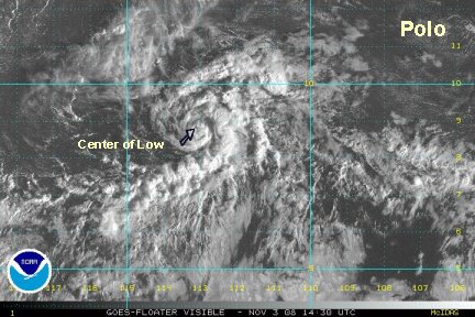
The latest satellite imagery shows a weakening trend. We think that tropical storm Polo is barely holding onto tropical storm strength. It appears that the convection is on the decline.

At 10 am pst Polo was centered near 8.9 N 113.5 W or about 985 ssw of Cabo San Lucas. It seems to be moving more slowly now moving wnw at around 10 mph.

Polo is not a threat to land.

TropicalWeather.net's Tropical Pic
Image
Rich Johnson
Twitter: https://twitter.com/richjohnsonwx
Certified Broadcast Meteorologist - Hurricane Expert
User avatar
Tropical Inspector
Site Admin
Site Admin
Posts: 3652
Joined: Tue Feb 20, 2007 2:28 pm
Antispam: no
Location: Under a palm tree
Contact:

Post by Tropical Inspector »

Tuesday Afternoon Update
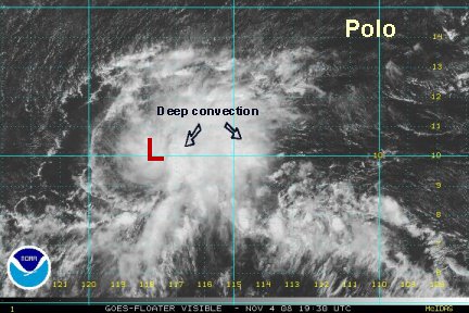
Polo strengthens a little

Polo has strengthened just a bit and looks to be just near or over 45 mph. Officially NHC has Polo at 40 mph on their last advisory. Deep convection has increased and is mainly on the eastern side of the circulation.

Polo is centered near 10.2 N / 117.7 W or just just over 1000 miles southwest of Cabo San Lucas.

Polo is not a threat to land.

TropicalWeather.net's Tropical Pic
Image
Rich Johnson
Twitter: https://twitter.com/richjohnsonwx
Certified Broadcast Meteorologist - Hurricane Expert
User avatar
Tropical Inspector
Site Admin
Site Admin
Posts: 3652
Joined: Tue Feb 20, 2007 2:28 pm
Antispam: no
Location: Under a palm tree
Contact:

Post by Tropical Inspector »

Polo is no longer a tropical depression. NHC mentioned that a quick scat satellite pass showed an open wave.
Rich Johnson
Twitter: https://twitter.com/richjohnsonwx
Certified Broadcast Meteorologist - Hurricane Expert
User avatar
Tropical Inspector
Site Admin
Site Admin
Posts: 3652
Joined: Tue Feb 20, 2007 2:28 pm
Antispam: no
Location: Under a palm tree
Contact:

Post by Tropical Inspector »

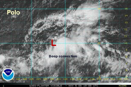
Wednesday Afternoon Update
Remnants of Polo moving west

As we mentioned earlier, The National Hurricane Center stopped writing advisories last night due to a Quickscat satellite pass indicating an open wave instead of a closed low. A newer Quickscat seems to indicate a weak low still which is consistent with the visible satellite imagery. Deep convection still is on the southeast side of the circulation. Top sustained winds are still probably near 30 mph in the convection.

The remnants of Polo are centered near 9.7 N / 122.4 W.

Polo is not a threat to land and this will be our last update, unless NHC reclassifies the tropical cyclone.

TropicalWeather.net's Tropical Pic
Image
Rich Johnson
Twitter: https://twitter.com/richjohnsonwx
Certified Broadcast Meteorologist - Hurricane Expert
Post Reply

Return to “2008 Eastern / Central Pacific Hurricane Season Archives”

Who is online

Users browsing this forum: No registered users and 0 guests