Beryl

Tropical cyclone archives for the 2012 Atlantic hurricane season
Post Reply
User avatar
Tropical Inspector
Site Admin
Site Admin
Posts: 3697
Joined: Tue Feb 20, 2007 2:28 pm
Antispam: no
Location: Under a palm tree
Contact:

Beryl

Post by Tropical Inspector »

Friday Morning Update

Subtropical system likely to form off of Southeast coast

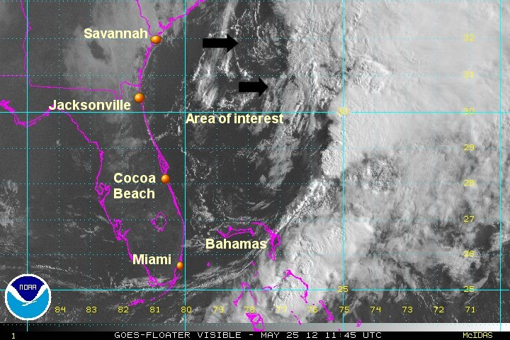
An elongated area of low pressure is north of the Bahamas. The deepest convection stretches from northeast of the Bahamas to well east of South Carolina. This is the zone where a subtropical system is predicted to form within the next 24 hours. Coolness of the water temperatures as well as a short time over water before landfall will reduce strengthening chances.

Forecast:
System 94L is predicted to form later today or tomorrow north of the Bahamas / off of the Georgia coast. In a similar fashion to Alberto last week, it should drift southwest. This should take it soutwest into northeastern Florida by Sunday.

Tropicast: Atlantic visible floater satellite
Image
Rich Johnson
Twitter: https://twitter.com/richjohnsonwx
Certified Broadcast Meteorologist - Hurricane Expert
User avatar
Tropical Inspector
Site Admin
Site Admin
Posts: 3697
Joined: Tue Feb 20, 2007 2:28 pm
Antispam: no
Location: Under a palm tree
Contact:

Re: 94L - north of the Bahamas

Post by Tropical Inspector »

Friday Afternoon Update

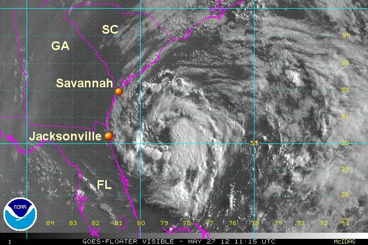
Low has formed east of Georgia coast

The latest satellite pictures confirm that a low pressure system in forming about 200 miles east southeast of Savannah, Georgia. Currently unsettled weather with the low is on the east side of the circulation - out to sea.

Forecast:
In a similar fashion to Alberto last week, 94L should drift southwest. This should take it southwest into northeastern Florida by Sunday.

Tropicast: Atlantic visible floater satellite
Image
Rich Johnson
Twitter: https://twitter.com/richjohnsonwx
Certified Broadcast Meteorologist - Hurricane Expert
User avatar
Tropical Inspector
Site Admin
Site Admin
Posts: 3697
Joined: Tue Feb 20, 2007 2:28 pm
Antispam: no
Location: Under a palm tree
Contact:

Re: Beryl

Post by Tropical Inspector »

Saturday morning Update

Beryl classified, moving toward coast

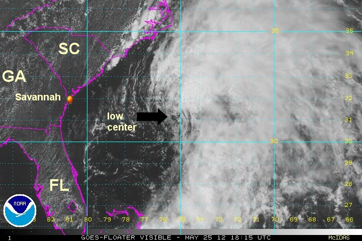
Beryl has a well defined circulation on visible satellite imagery. It is moving southwest toward the coast of Georgia / extreme northeast Florida. Most of the deep convestion ( heavy storms ) are displaced away from the low center.

As of 9 am edt Beryl was centered at 31.9 N / 76.1 W or about 230 miles ese of Charleston, South Carolina. It was moving wsw at about 5 mph. Top sustained winds estimated at 45 mph ( 45 mph NHC advisory). Pressure was estimated at 1001 mb.

Forecast:
Beryl is predicted to move southwest toward the coast of Georgia / northeast Florida by late Sunday. It is expected to be a tropical storm at landfall. Remember, many times the worst of the weather is not associated with the landfall time of a tropical storm.

Tropicast: Atlantic visible floater satellite
Image
Rich Johnson
Twitter: https://twitter.com/richjohnsonwx
Certified Broadcast Meteorologist - Hurricane Expert
User avatar
Tropical Inspector
Site Admin
Site Admin
Posts: 3697
Joined: Tue Feb 20, 2007 2:28 pm
Antispam: no
Location: Under a palm tree
Contact:

Re: Beryl

Post by Tropical Inspector »

Saturday evening Update

Beryl a little stronger, becoming tropical

Subtropical storm Beryl is gaining tropical characteristics. It has looked like a large low center associated with a mid latitude occlusion. The low center is now breaking away from the larger mass of clouds and is becoming its own identity. With this occuring, Beryl will likely become a tropical before landfall near Jacksonville late Sunday.

There is a large low center of circulation which is not an eye. Winds are being raised up from the Hurricane Hunter data..

As of 9 pm edt Beryl was centered at 31.1 N / 76.9 W or about 285 east of Jacksonville, FL. It was moving sw at about 6 mph. Top sustained winds estimated at 50 mph ( 50 mph NHC advisory). Pressure was estimated at 998 mb.

Forecast:
Beryl is predicted to move southwest toward the coast of Georgia / northeast Florida by late Sunday. It is expected to be a tropical storm at landfall. Remember, many times the worst of the weather is not associated with the landfall time of a tropical storm.

Tropicast: Atlantic visible floater satellite
Image
Rich Johnson
Twitter: https://twitter.com/richjohnsonwx
Certified Broadcast Meteorologist - Hurricane Expert
User avatar
Tropical Inspector
Site Admin
Site Admin
Posts: 3697
Joined: Tue Feb 20, 2007 2:28 pm
Antispam: no
Location: Under a palm tree
Contact:

Re: Beryl

Post by Tropical Inspector »

Sunday morning Update

Beryl heading toward Jacksonville

A very rare landfall for Jacksonville is likely later today. Beryl now appears to be a tropical storm instead of a tropical storm as it now has totally broken away from a mid latitude weather system. A turn to the west is now occuring from wsw. The deepest convection is on the east or ocean side of the storm. There will be the possibility of a small storm surge of about 1-3 feet if landfall lines up with high tide.

Very beneficial rainfall will occur over parts of north Florida and south Georgia.


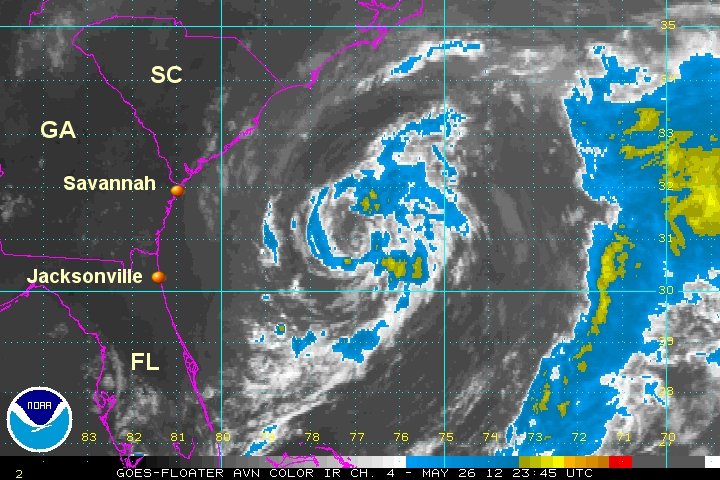
As of 8 am edt Beryl was centered at 30.3 N / 78.9 W or about 165 miles east of Jacksonville, FL / 180 miles se of Savannah, GA. It was moving wsw at about 10 mph. Top sustained winds estimated at 50 mph ( 50 mph NHC advisory). Pressure was estimated at 998 mb.

Forecast:
Beryl is predicted to make landfall late today and remain over land near the coast for the next 2-3 days. This track will take it inland in extreme northeast Florida near Jacksonville. It will then recurve northeast just inland across the coast of Georgia and South Carolina. Beryl should reemerge near the South Carolina coast Wednesday and move offshore of North Carolina - possibly becoming a storm again as it moves out to sea.

Tropicast: Atlantic visible floater satellite
Image
Rich Johnson
Twitter: https://twitter.com/richjohnsonwx
Certified Broadcast Meteorologist - Hurricane Expert
User avatar
Tropical Inspector
Site Admin
Site Admin
Posts: 3697
Joined: Tue Feb 20, 2007 2:28 pm
Antispam: no
Location: Under a palm tree
Contact:

Re: Beryl

Post by Tropical Inspector »

Sunday evening Update

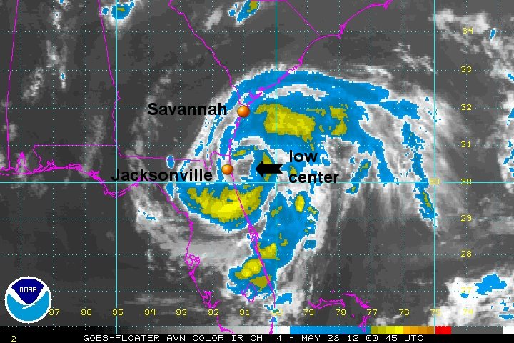
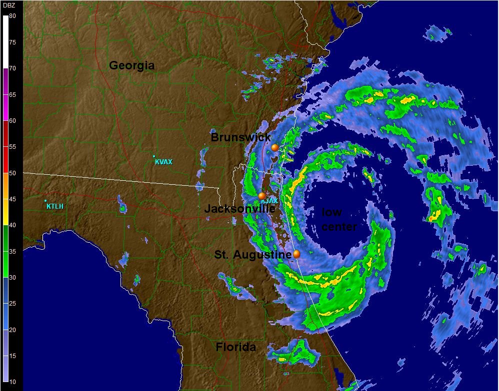
Beryl just east of Jacksonville

Beryl has strengthened today and is just shy of becoming a hurricane. It's possible that it may classified as one with another five or six hours over water. Winds have gusted to around 40 mph so far at Jacksonville. Top seas today were around 14-15' feet measured by an offshore buoy. Seas will start subsiding later tonight and tomorrow as Beryl moves inland. The hurricane hunter measured a flight level winds of about 95 mph earlier this evening

As of 9 pm edt Beryl was centered at 30.1 N / 80.6 W or about 65 miles east of Jacksonville, FL. It was moving west at about 10 mph. Top sustained winds estimated at 70 mph (70 mph NHC advisory). Pressure was estimated at 992 mb. .

Forecast:
Beryl is predicted to make landfall just after midnight and remain over land near the coast for the next 2-3 days. It will then recurve northeast just inland across the coast of Georgia and South Carolina. Beryl should reemerge near the South Carolina coast Wednesday and move offshore of North Carolina - possibly becoming a storm again as it moves out to sea.

Tropicast: Atlantic IR floater satellite
Image

Tropicast: Jacksonville Radar
Image
Rich Johnson
Twitter: https://twitter.com/richjohnsonwx
Certified Broadcast Meteorologist - Hurricane Expert
User avatar
Tropical Inspector
Site Admin
Site Admin
Posts: 3697
Joined: Tue Feb 20, 2007 2:28 pm
Antispam: no
Location: Under a palm tree
Contact:

Re: Beryl

Post by Tropical Inspector »

Monday Morning Update

Beryl west of Jacksonville

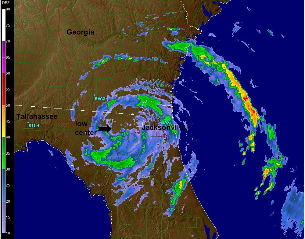
Beryl made landfall just after midnight with top sustained winds of 70 mph. This may have been an overestimation with no reporting stations measuring winds that strong. Mayport reported winds sustained at 44 mph with gusts to 59 mph. Jacksonville had a gust to 49 mph. NHC is holding onto Beryl as a minimal tropical storm, but I believe that it is now weaker. The strongest winds will be offshore in a few squall bands.

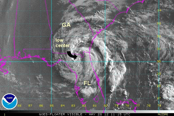
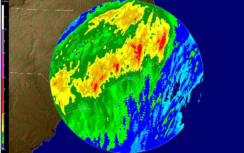
This morning the center of Beryl is over the Big Bend of Florida with the center of the low now clouded over. Beneficial rainfall is occuring over north Florida and southeast Georiga.

As of 8 am edt Beryl was centered at 30.4 N / 82.5 W or about 50 miles west of Jacksonville, FL. It was moving west at about 8 mph. Top sustained winds estimated at 35 mph (40 mph NHC advisory). Pressure was estimated at 1000 mb.

Forecast:
Beryl will recurve northeast from just east of Tallahassee, then across the coast of Georgia and South Carolina. Beryl should reemerge near the South Carolina coast Wednesday and move offshore of North Carolina - possibly becoming a storm again as it moves out to sea.

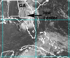
Tropicast: Atlantic Visible floater satellite
Image

Tropicast: Jacksonville Radar
Image
Rich Johnson
Twitter: https://twitter.com/richjohnsonwx
Certified Broadcast Meteorologist - Hurricane Expert
User avatar
Tropical Inspector
Site Admin
Site Admin
Posts: 3697
Joined: Tue Feb 20, 2007 2:28 pm
Antispam: no
Location: Under a palm tree
Contact:

Re: Beryl

Post by Tropical Inspector »

Here are a few more report from Kirk Mellish:

‎73 mph at Buck Island, Fla. (1mph below hurricane)

- 3 people and a dog rescued from sinking boat in Charleston Harbor, S.C. 4' seas reported in the harbor.

- Water reported up to the dune line at Jacksonville Beach at the time of landfall. 6' surf reported.

- Over 26,000 in northeast Florida and south Georgia were without power.

Strong winds estimated near 65 mph in Harrietts Bluff, Ga. Reports of pine trees and large branches blown down.

A tree has fallen on a house in Kingsland, Ga. No injuries were reported.
________________________________________________________________________________________

A tropical storm of 70 mph sustained should have produced winds of at least 85 mph. IMO Beryl was not a 70 mph tropical storm.
Rich Johnson
Twitter: https://twitter.com/richjohnsonwx
Certified Broadcast Meteorologist - Hurricane Expert
User avatar
Tropical Inspector
Site Admin
Site Admin
Posts: 3697
Joined: Tue Feb 20, 2007 2:28 pm
Antispam: no
Location: Under a palm tree
Contact:

Re: Beryl

Post by Tropical Inspector »

Tuesday Morning Update

Beryl moving across south Georgia

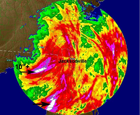
Beryl is bringing drought breaking rains to north Florida and south Georgia. Rainfall amounts of 2-5" have been common across the region with totals over 10" estimated by doppler radar. Heavy rain will advance into eastern South and North Carolina as it make its way toward the coast. Boaters off of the Carolina coasts should be prepared for Beryl to redevelop off shore Wednesday.

As of 8 am edt Beryl was centered at XX.X N / XX..X W or about 30 miles northeast of Valdosta, GA. It was moving northeast at about 5 mph. Top sustained winds estimated at 25 mph (30 mph NHC advisory). Pressure was estimated at 1005 mb.

Forecast:
Beryl has recurved and is moving across south Georgia today. Beryl will reemerge off of the South Carolina coast Wednesday and move offshore of North Carolina - likely becoming a storm again as it moves out to sea.

Tropicast: Atlantic Visible floater satellite
Image

Tropicast: Rainfall estimate Radar as of Tuesday Morning
Image
Rich Johnson
Twitter: https://twitter.com/richjohnsonwx
Certified Broadcast Meteorologist - Hurricane Expert
User avatar
Tropical Inspector
Site Admin
Site Admin
Posts: 3697
Joined: Tue Feb 20, 2007 2:28 pm
Antispam: no
Location: Under a palm tree
Contact:

Re: Beryl

Post by Tropical Inspector »

Wednesday Morning Update

Beryl moving offshore south of Myrtle Beach

Beryl is now just offshore. This will allow for it to become a tropical storm again shortly as it passes over the water warm waters of the Gulf Stream. Very heavy rainfall is moving into eastern North Carolina where rainfall totals in excess of 5" can be expected.

As of 8 am edt Beryl was centered at XX.X N / XX..X W or just south of Myrtle Beach, SC. It was moving ene at about 14 mph. Top sustained winds estimated at 35 mph (35 mph NHC advisory). Pressure was estimated at 1001 mb.

Forecast:
Beryl is near Myrtle Beach, SC this morning. It will move offshore of North Carolina late today - becoming a storm again as it moves out to sea well east of the Virginia Capes.

Tropicast: Atlantic Visible floater satellite
Image

Tropicast: Radar Wednesday 8AM edt
Image
Rich Johnson
Twitter: https://twitter.com/richjohnsonwx
Certified Broadcast Meteorologist - Hurricane Expert
User avatar
Tropical Inspector
Site Admin
Site Admin
Posts: 3697
Joined: Tue Feb 20, 2007 2:28 pm
Antispam: no
Location: Under a palm tree
Contact:

Re: Beryl

Post by Tropical Inspector »

Wednesday Evening Update

Beryl post tropical, moving out

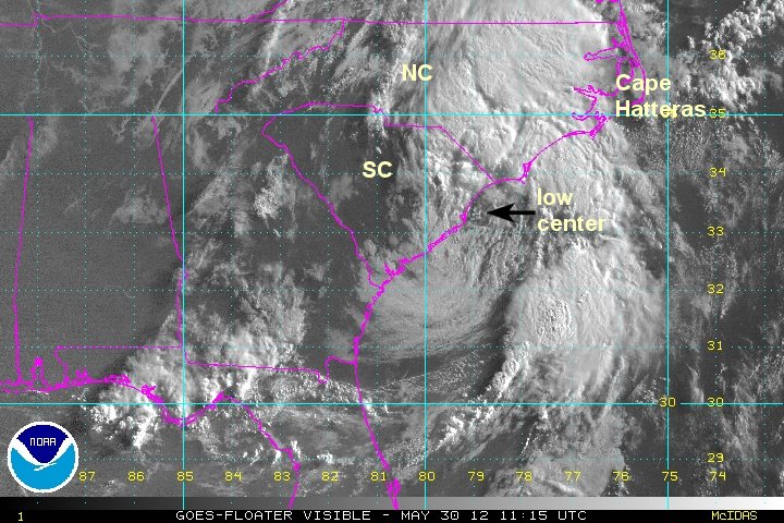
Beryl is offshore and is moving away from eastern NC. Rainfall totals were generally 1-3" with a few totals estimated at 3-5".

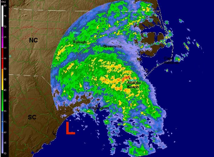
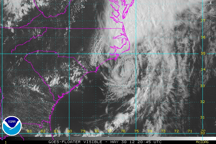
As of 5 pm edt Beryl was centered at 34.9 N / 76.1 W or 40 miles wsw of Cape Hatteras, NC. It was moving ene at about 21 mph. Top sustained winds estimated at 40 mph (40 mph NHC advisory). Pressure was estimated at 998 mb.

Forecast:
Beryl will continue to move east, away from the U.S. as an extratropical cyclone.

Tropicast: Atlantic Visible floater satellite
Image

Tropicast: Radar rain totals Wednesday afternoon
Image
Rich Johnson
Twitter: https://twitter.com/richjohnsonwx
Certified Broadcast Meteorologist - Hurricane Expert
Post Reply

Return to “2012 Atlantic Hurricane Season Archives”

Who is online

Users browsing this forum: No registered users and 1 guest