12 E

Tropical cyclone archives of the 2011 eastern and central Pacific hurricane season
Post Reply
User avatar
Tropical Inspector
Site Admin
Site Admin
Posts: 3697
Joined: Tue Feb 20, 2007 2:28 pm
Antispam: no
Location: Under a palm tree
Contact:

12 E

Post by Tropical Inspector »

Wednesday Morning Update

12 E (Kenneth) in Gulf of Tehuantepec

The tropical disturbance that has been offshore for days has quickly organized overnight into tropical storm Kenneth (unofficially) Deep convection has increased enough to say that 12 E should be classifiend as a tropical storm. It will move inland this evening in southern Mexico which will halt strengthening.

As of 8 am edt / 5 am pdt Kenneth (12 E) was centered near 15.2 N / 93.5 W or about 125 miles se of Salina Cruz, Mexico. Movement is north at about 5 mph. Top sustained winds are estimated at 40 mph (NHC 35 mph earlier advisory). Pressure is estimated at 1002 mb.

Forecast:
Kenneth will have a short life span as it is forecast to move north and be inland in about 12-18 hours in southern Mexico.

Tropicast: Pacific IR Satellite
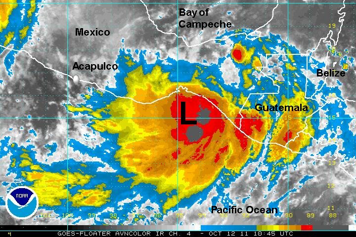
Image
Rich Johnson
Twitter: https://twitter.com/richjohnsonwx
Certified Broadcast Meteorologist - Hurricane Expert
User avatar
Tropical Inspector
Site Admin
Site Admin
Posts: 3697
Joined: Tue Feb 20, 2007 2:28 pm
Antispam: no
Location: Under a palm tree
Contact:

Re: 12 E

Post by Tropical Inspector »

12 E has moved inland. It appeared that there was sufficient data to classify 12 E as a minimal tropical storm this morning. It is now weakening over land.
Rich Johnson
Twitter: https://twitter.com/richjohnsonwx
Certified Broadcast Meteorologist - Hurricane Expert
Post Reply

Return to “2011 Eastern / Central Pacific Hurricane Season Archives”

Who is online

Users browsing this forum: No registered users and 1 guest