Igor

Tropical cyclone archives for the 2010 Atlantic hurricane season
User avatar
Tropical Inspector
Site Admin
Site Admin
Posts: 3581
Joined: Tue Feb 20, 2007 2:28 pm
Antispam: no
Location: Under a palm tree
Contact:

Re: Igor

Post by Tropical Inspector »

Sunday Morning Update

Wind, rain increasing on Berumda

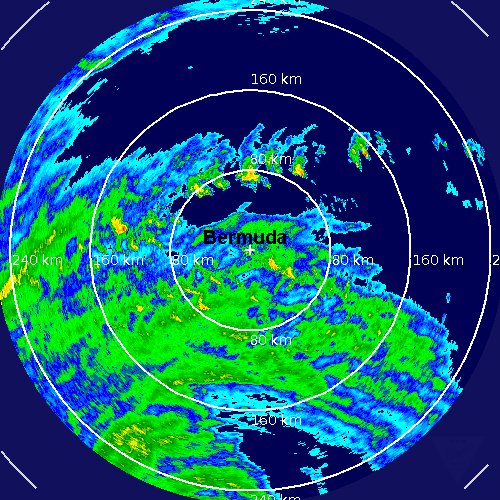
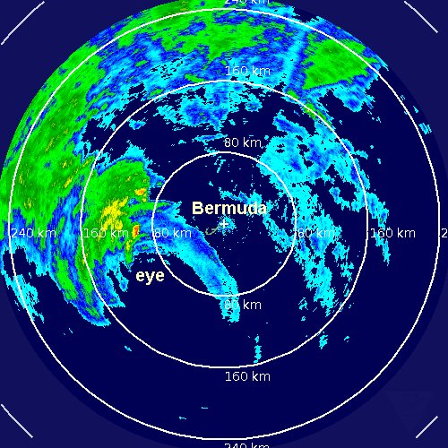
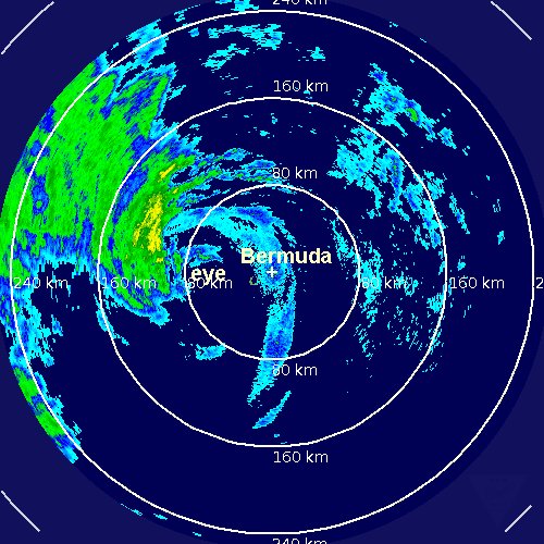
Thankfully Igor has continued its slow, methodical weakening overnight. Top sustained winds are now 85 mph. Bermuda still will have Igor move very close this evening. Winds on Bermuda now are about 30 mph gusting to 50 mph. Bermuda will have a prolonged period of wind and heavy rain since Igor is a large hurricane. Swell will be one of the main problems with seas now over 20 feet hundreds of miles away from the center of Igor. The impacts at Bermuda will be very rough seas, heavy rain, strong winds in the cat 1 range (assuming no significant change in strength occurs today).

It appears that the media well over exaggerated Igor. Last evening terms like "monster hurricane" and "worst ever" were used to describe the hurricane. It is a disservice to meteorologists when news agencies use terms like this to gets ratings. Many times meteorologists who are not hurricane experts will be used to report on "stories" like this to no fault of their own..... Sorry about the soapbox. I just feel it is important to get the right facts to the public when a hurricane is threatening

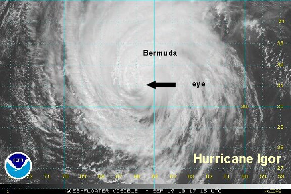
As of 8 am edt / ast hurricane Igor was centered near 29.6° N / 65.3° W or about 190 miles south of Bermuda. Top sustained winds are estimated at 85 mph (NHC 85 mph 8 am ast advisory). Movement is north at 13 mph. Pressure at 949 mb by the recon.

Forecasts call for Igor to be in the vicinity of Bermuda by around 10 - 11 pm this evening. It looks like Igor will be a cat 1 hurricane near Bermuda.

Tropicast: Visible Floater Satellite
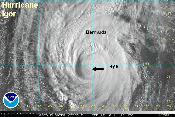
Image


Tropicast 2: Bermuda Radar
Image
Rich Johnson
Twitter: https://twitter.com/richjohnsonwx
Certified Broadcast Meteorologist - Hurricane Expert
User avatar
Tropical Inspector
Site Admin
Site Admin
Posts: 3581
Joined: Tue Feb 20, 2007 2:28 pm
Antispam: no
Location: Under a palm tree
Contact:

Re: Igor

Post by Tropical Inspector »

Sunday Afternoon Update

Winds gusting to hurricane force on Bermuda

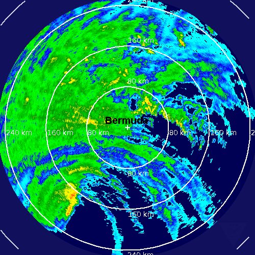
Winds are now steady at about 50 mph on Bermuda with gusts to 70-75 mph. The worst part of the hurricane is to the west and southwest of Bermuda. If Igor continues on its current path, the eye will pass west of the island. Look for conditions to deteriorate for the rest of the afternoon, then start to slowly get better overnight tonight as the hurricane pulls away. Large swell over 25 feet is now near Bermuda. The south facing beaches are most vulnerable.

As of 2 pm edt / ast hurricane Igor was centered near 30.8° N / 65.7° W or about 115 miles south southwest of Bermuda. Top sustaind winds are estimated at 85 mph (NHC 85 mph 2 pm ast advisory). Movement is north at 15 mph. Pressure at 952 mb by the recon.

Forecasts call for Igor to be near or just west of Bermuda by around 10 pm this evening. It looks like Igor will be a cat 1 hurricane near Bermuda.

Tropicast: Visible Floater Satellite
Image


Tropicast 2: Bermuda Radar
Image
Rich Johnson
Twitter: https://twitter.com/richjohnsonwx
Certified Broadcast Meteorologist - Hurricane Expert
User avatar
Tropical Inspector
Site Admin
Site Admin
Posts: 3581
Joined: Tue Feb 20, 2007 2:28 pm
Antispam: no
Location: Under a palm tree
Contact:

Re: Igor

Post by Tropical Inspector »

Sunday Night Update

Igor west southwest of Bermuda

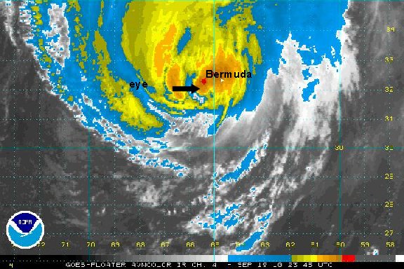
It look like Bermuda will escape the worst effects of Igor. It is west southwest of Bermuda and will pass about 30-40 miles to the west. The worst effects are already past with the north side of the circulation carrying the most heavy rain and squalls.

As of 8 pm edt / ast hurricane Igor was centered near 31.9° N / 65.7° W or about 60 miles west southwest of Bermuda. Top sustaind winds are estimated at 75 mph (NHC 75 mph 8 pm ast advisory). Movement is north northeast at 14 mph. Pressure at 953 mb by the recon.

Tropicast: I.R. Floater Satellite Imagery
Image

Tropicast 2: Bermuda Radar
Image
Rich Johnson
Twitter: https://twitter.com/richjohnsonwx
Certified Broadcast Meteorologist - Hurricane Expert
User avatar
Tropical Inspector
Site Admin
Site Admin
Posts: 3581
Joined: Tue Feb 20, 2007 2:28 pm
Antispam: no
Location: Under a palm tree
Contact:

Re: Igor

Post by Tropical Inspector »

Sunday Night #2 Update

Igor passing Bermuda to the west

Hurricane Igor is passing Bermuda to the west by about 40 miles. The strongest part of the eyewall is northwest of the center meaning that the slightly stronger effects will not be seen in Bermuda. Look for conditions to slowly improve throughout tonight. It looks like Bermuda will not see sustained hurricane force winds, only gusts to minimal hurricane force.

As of 11 pm edt / ast hurricane Igor was centered near 32.4 N / 65.5° W or about 40 miles west of Bermuda. Top sustaind winds are estimated at 75 mph (NHC 75 mph 11 pm ast advisory). Movement is north northeast at 14 mph. Pressure at 955 mb by the recon.

This will be the last update on Igor. It should be a tropical storm very shortly as weakening continues. It will then become an extratropical cyclone as it moves toward the northern north Atlantic ocean.

Tropicast 2: Bermuda Radar
Image
Rich Johnson
Twitter: https://twitter.com/richjohnsonwx
Certified Broadcast Meteorologist - Hurricane Expert
Post Reply

Return to “2010 Atlantic Hurricane Season Archives”

Who is online

Users browsing this forum: No registered users and 1 guest