Tropical depression 1

Tropical cyclone archives for the 2009 Atlantic hurricane season
Post Reply
User avatar
Tropical Inspector
Site Admin
Site Admin
Posts: 3691
Joined: Tue Feb 20, 2007 2:28 pm
Antispam: no
Location: Under a palm tree
Contact:

Tropical depression 1

Post by Tropical Inspector »

Thursday Morning Update

Low has formed east of the Mid-Atlantic coast

The Atlantic hurricane season threatens to start early again...

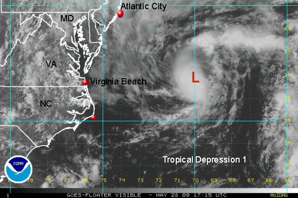
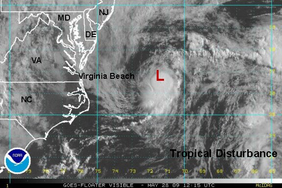
A new low has formed east of Virginia Beach by about 250 miles. This low, even if it develops some, will not be a threat to the northeastern U.S.. It is possible that this system could be classified as a tropical depression. The system has formed near the Gulf Stream where water temperatures are considerably water than near shore. Upper air winds will move this system to the east northeast away from land.

Tropicast: Mid-Atlantic Visible Satellite
Image

Visible satellite shows deep convection associated with the disturbance. It appeared that the disturbance was to the north of the convection earlier this morning. Apparently some of the west southwest wind shear has relaxed and the convection has built more over the center of circulation.
Rich Johnson
Twitter: https://twitter.com/richjohnsonwx
Certified Broadcast Meteorologist - Hurricane Expert
User avatar
Tropical Inspector
Site Admin
Site Admin
Posts: 3691
Joined: Tue Feb 20, 2007 2:28 pm
Antispam: no
Location: Under a palm tree
Contact:

First tropical depression forms east of Virginia Beach

Post by Tropical Inspector »

Thursday Afternoon Update

Tropical depression one staying offshore of U.S. east coast

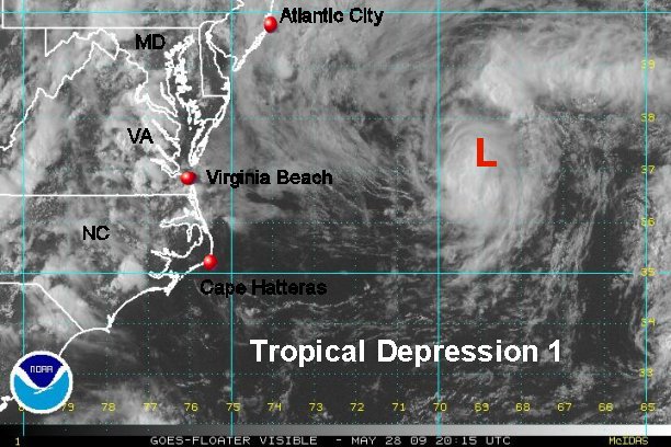
There is a good chance that t.d. 1 of the Atlantic hurricane season will be upgraded to tropical storm Ana at 5 pm edt. The tropical depression continues to organize about 250 miles southeast of Atlantic City, NJ. It will not affect the U.S. east coast in any significant way. Seas may be slightly higher than normal in the Northeast over the next day or two.

Forecast models are consistent with keeping the tropical depression (storm) offshore.


Tropicast: Mid-Atlantic Visible Satellite
Image

The visible satellite imagery shows that the depression continues to quickly organize and parallel the U.S. east coast well offshore. Deep convection if over the center of circulation and it is our estimation that this depression is on the verge of becoming tropical storm Ana.
Rich Johnson
Twitter: https://twitter.com/richjohnsonwx
Certified Broadcast Meteorologist - Hurricane Expert
User avatar
Tropical Inspector
Site Admin
Site Admin
Posts: 3691
Joined: Tue Feb 20, 2007 2:28 pm
Antispam: no
Location: Under a palm tree
Contact:

Re: First tropical depression forms east of Virginia Beach

Post by Tropical Inspector »

Thursday Evening Update

Tropical depression 1 weakening some


There has been no change in NHC's advisory strength from the 11 am edt advisory. The depression is still officially 35 mph. We believe that t.d. 1 actually reached tropical storm strength early this afternoon. We estimated 40 mph sustained for several hours early to mid afternoon. The depression appears to be fighting some wind shear again. T.D. 1 may have missed it's chance to become the first named storm.


Tropicast: Mid-Atlantic Visible Satellite
Image

After reviewing visible and I.R. satellite imagery, it appears that the structure of the tropical depression 1 is now becoming more disorganized. The I.R. imagery shows warming cloud tops indicating that the convection is waning. If this trend continues, t.d. 1 will be history by 24-36 hours as it moves over colder water.
Rich Johnson
Twitter: https://twitter.com/richjohnsonwx
Certified Broadcast Meteorologist - Hurricane Expert
User avatar
Tropical Inspector
Site Admin
Site Admin
Posts: 3691
Joined: Tue Feb 20, 2007 2:28 pm
Antispam: no
Location: Under a palm tree
Contact:

Re: First tropical depression forms east of Virginia Beach

Post by Tropical Inspector »

Thursday Night Update

Tropical depression 1 continues away from Northeast

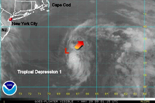
The depression is centered about 250 miles southeast of Nantucket, MA. It is moving northeast, paralleling the U.S. east coast. Our estimate is that winds are no stronger than 35 mph and may be closer to 30 mph.

The tropical depression has not changed considerably since our last update several hours ago. If anything, the low level circulation is becoming more exposed. This is a sign of weakening. There should be essentially no noticeable effects in the northeastern U.S.. This low will lose its tropical characteristics as it continues toward the shipping lanes of the North Atlantic. Tomorrow will likely be the last advisory on this system.

Tropicast: Mid-Atlantic I.R. Satellite
Image

Satellite shows that the low level circulation is on the northwest side of the circulation. Only minimal convection is noticed on the southeast portion of the circulation. The chances are low of the tropical depression making a significant comeback as it heads northeast over cooler water.
Rich Johnson
Twitter: https://twitter.com/richjohnsonwx
Certified Broadcast Meteorologist - Hurricane Expert
User avatar
Tropical Inspector
Site Admin
Site Admin
Posts: 3691
Joined: Tue Feb 20, 2007 2:28 pm
Antispam: no
Location: Under a palm tree
Contact:

Re: First tropical depression forms east of Virginia Beach

Post by Tropical Inspector »

Friday Morning Update

Tropical depression 1 south of Nova Scotia

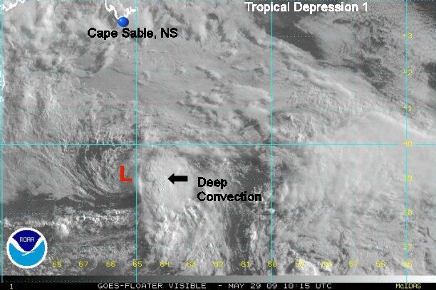
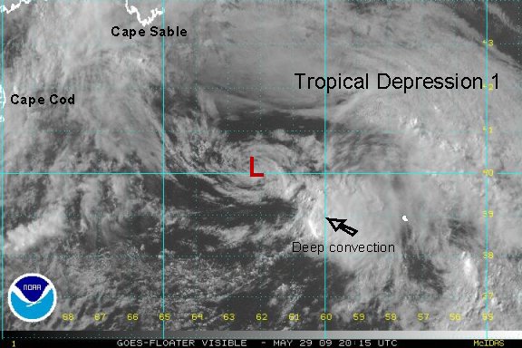
T.D. 1 is centered about 290 miles south of Cape Sable, Nova Scotia moving east northeast at about 15 mph. Top sustained winds are still near 35 mph in the convection southeast of the low center.

After a someone impressive flare up of convection (although short lived), the tropical depression is now continuing to fight westerly wind shear. It is moving steadily away from the eastern U.S..

Tropicast: Mid-Atlantic Visible Satellite
Image

The upper air winds are not only guiding tropical depression 1 away from the U.S., they are also shearing the system apart. The upper westerly winds are keeping the convection on the east side of the circulation, especially southeast.
Rich Johnson
Twitter: https://twitter.com/richjohnsonwx
Certified Broadcast Meteorologist - Hurricane Expert
User avatar
Tropical Inspector
Site Admin
Site Admin
Posts: 3691
Joined: Tue Feb 20, 2007 2:28 pm
Antispam: no
Location: Under a palm tree
Contact:

Re: Tropical depression 1

Post by Tropical Inspector »

Friday Evening Update

Tropical depression has become extratropical

Tropical depression 1 had its convection totally stripped by upper air winds today. It has now entered colder waters and has lost its tropical characteristics.

Here is the last visible satellite picture. Good bye tropical depression 1. :cheers:

Tropicast: Mid-Atlantic Visible Satellite
Image
Rich Johnson
Twitter: https://twitter.com/richjohnsonwx
Certified Broadcast Meteorologist - Hurricane Expert
Post Reply

Return to “2009 Atlantic Hurricane Season Archives”

Who is online

Users browsing this forum: No registered users and 1 guest