Vorticities of disorganization
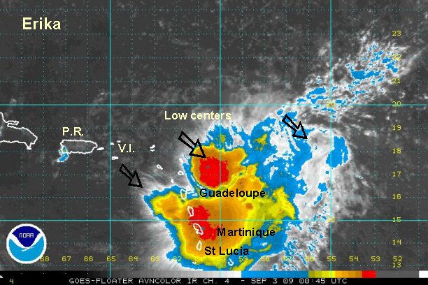
Erika is a very unusual tropical system. To call it a tropical storm is a bit misleading. On the satellite imagery at least three centers can be seen. Occasionally with a tropical storm a weak vorticity will spin around the circulation. With Erika, it is hard to determine which of the centers is the dominate one. I really don't recall a tropical storm looking like this. It is a sure sign of disorganization. Even disorganized systems can bring heavy rain, like that which is falling over the northern Windwards now.
Another point of concern is with the forecast. Which center of circulation will the models pick up? Hopefully some of the better models have the right trend where they keep it disorganized and weak. The models are much farther west taking what's left of Erika through the northern Antilles. There is still quite a bit of convection with heavy downpours with Erika and will likely continue farther west if it is a storm or not.
Low centers are 1) 16.2° N / 63.4° W or 125 miles west of Guadeloupe moving west southwest at about 6 mph 2) 17.8° N / 60.8° W or 65 miles east of Barbuda moving west at about 8 mph 3) 17.8° N / 60.8° or about 385 miles east northeast of the Lesser Antilles - drifting north northwest.
This is almost absurd to report positions of multiple centers. I don't recall having to do this with one low not being dominate. Top sustained winds are estimated at 40 mph under the deep convection - this is probably generous. Seas are at 15' near the deep convection.
Tropicast: Atlantic I.R. Floater Satellite (8:15 pm edt)

