Iselle

Tropicial cyclone archives of the 2008 eastern and central Pacific hurricane season
Post Reply
User avatar
Tropical Inspector
Site Admin
Site Admin
Posts: 3691
Joined: Tue Feb 20, 2007 2:28 pm
Antispam: no
Location: Under a palm tree
Contact:

Iselle

Post by Tropical Inspector »

Wednesday Late Morning Update

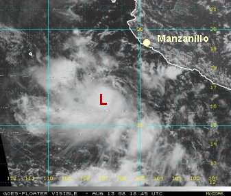
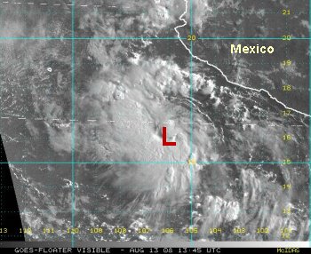
Deep convection has exploded with the disturbance that we have been watching for the past few days. It is centered near 16.3 N 105.8 W or about 210 miles south-southwest of Manzanillo. It is moving west-northwest and should pass well south of Cabo. Increasing swell will be the main, if not the only threat to Mexico. NHC has it as 35 mph, but it probably is tropical storm Iselle at 40 or 45 mph by our estimate.

TropicalWeather.net's Tropical Pic
Image
Rich Johnson
Twitter: https://twitter.com/richjohnsonwx
Certified Broadcast Meteorologist - Hurricane Expert
User avatar
Tropical Inspector
Site Admin
Site Admin
Posts: 3691
Joined: Tue Feb 20, 2007 2:28 pm
Antispam: no
Location: Under a palm tree
Contact:

Post by Tropical Inspector »

Wednesday Afternoon Update
Cat out of the bag

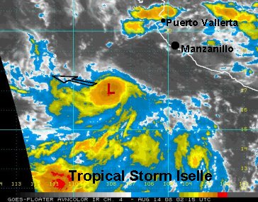
It looks like NHC will upgrade the tropical depression to agree with our earlier assesment of the tropical depression. We came across a tropical storm designation on a website connected to NHC. So it looks like officially at 5 pm they will upgrade to Iselle also.

The latest satellite imagery actually doesn't look as impressive as earlier, but the circulation is ample with the convection to say that the system is about 40 mph sustained.

At 4 pm edt the center of circulation was near 16.5 N / 106.7 W or about 225 miles southwest of Manzanillo, MX. Movement is west away from Mexico. Swell appears to be the only effect on Mexico.


TropicalWeather.net's Tropical Pic
Image
Rich Johnson
Twitter: https://twitter.com/richjohnsonwx
Certified Broadcast Meteorologist - Hurricane Expert
User avatar
Tropical Inspector
Site Admin
Site Admin
Posts: 3691
Joined: Tue Feb 20, 2007 2:28 pm
Antispam: no
Location: Under a palm tree
Contact:

Post by Tropical Inspector »

Wednesday Evening Mini Update
NHC officially did name Iselle at 5 pm edt (2 pm pdt). 40 mph. ;-)
Rich Johnson
Twitter: https://twitter.com/richjohnsonwx
Certified Broadcast Meteorologist - Hurricane Expert
User avatar
Tropical Inspector
Site Admin
Site Admin
Posts: 3691
Joined: Tue Feb 20, 2007 2:28 pm
Antispam: no
Location: Under a palm tree
Contact:

Post by Tropical Inspector »

Wednesday Night Update
Iselle slowly pulling away from Mexico

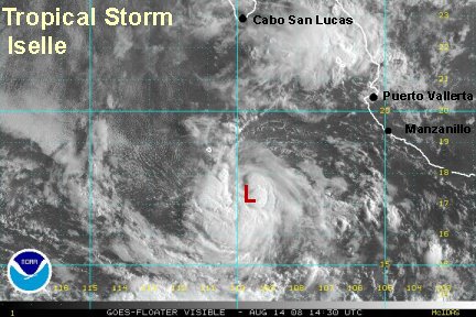
Tropical storm Iselle is centered near 16.7 N / 108.0 W or about 275 miles southwest of Manzanillo. The low is under the deepest convection as it moves west-northwest away from Mexico at around 12 mph. A few models turn the storm northward toward Cabo. Most take is well south of Cabo. Right now we think it should stay south, but will watch for any deviant treands.

TropicalWeather.net's Tropical Pic
Image
Rich Johnson
Twitter: https://twitter.com/richjohnsonwx
Certified Broadcast Meteorologist - Hurricane Expert
User avatar
Tropical Inspector
Site Admin
Site Admin
Posts: 3691
Joined: Tue Feb 20, 2007 2:28 pm
Antispam: no
Location: Under a palm tree
Contact:

Post by Tropical Inspector »

Thursday Midday Update
Iselle a little stronger

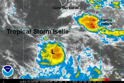
Tropical storm Iselle is centered near 17.8 N / 109.4 W or about 355 miles south of Cabo. The only notice of Iselle to Mexico will be an increase in swell. It is slowly moving northwest at around 8 mph.


TropicalWeather.net's Tropical Pic
Image
Rich Johnson
Twitter: https://twitter.com/richjohnsonwx
Certified Broadcast Meteorologist - Hurricane Expert
User avatar
Tropical Inspector
Site Admin
Site Admin
Posts: 3691
Joined: Tue Feb 20, 2007 2:28 pm
Antispam: no
Location: Under a palm tree
Contact:

Post by Tropical Inspector »

Friday Early AM Update
Iselle no threat, moving away from Mexico

Tropical storm Iselle is centered about 370 miles south-southwest of Cabo. It is slowly moving west at around 9 mph. Higher than normal swell may be experienced near Cabo. Since Iselle is no threat to Mexico and moving farther away, this will be the last update.


TropicalWeather.net's Tropical Pic
Image
Rich Johnson
Twitter: https://twitter.com/richjohnsonwx
Certified Broadcast Meteorologist - Hurricane Expert
Post Reply

Return to “2008 Eastern / Central Pacific Hurricane Season Archives”

Who is online

Users browsing this forum: No registered users and 1 guest