Fausto

Tropicial cyclone archives of the 2008 eastern and central Pacific hurricane season
Post Reply
User avatar
Tropical Inspector
Site Admin
Site Admin
Posts: 3694
Joined: Tue Feb 20, 2007 2:28 pm
Antispam: no
Location: Under a palm tree
Contact:

Fausto

Post by Tropical Inspector »

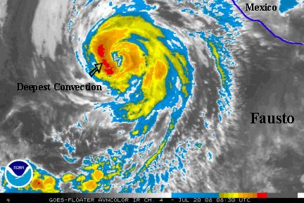
Saturday Night Update
Hurricane Fausto is now at 85 mph and is moving northwest. It is about 450 miles south of Cabo San Lucas.

Fausto's main effects will be swell on the west coast of Mexico, expecially in the southern Baja. A few showers are possible too. Fausto poses little threat to Mexico.

Forecast models take Fausto northwest, gradually toward cooler water. this should slowly weaken Fausto. It's possible that in the short term some strengthening is possible, as noted by the deep convection burst near the center of circulation.


TropicalWeather.net's Tropical Pic
Image
Rich Johnson
Twitter: https://twitter.com/richjohnsonwx
Certified Broadcast Meteorologist - Hurricane Expert
User avatar
Tropical Inspector
Site Admin
Site Admin
Posts: 3694
Joined: Tue Feb 20, 2007 2:28 pm
Antispam: no
Location: Under a palm tree
Contact:

Post by Tropical Inspector »

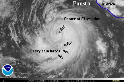
Sunday Morning Update
Hurricane Fausto is still at 85 mph and is moving northwest. It is about 380 miles south-southwest of Cabo San Lucas. The temporary strengthening looks to have occured and Fausto looks to now really be about 85 mph. It looked a little weaker to us on the last update.

The forecast models are steady and keep Fausto away from Baja as it slowly moves over cooler water. Fausto may still strengthen some before being impacted by the effects of cooler ocean water. The main effects to Mexico will be swell.


TropicalWeather.net's Tropical Pic
Image
Rich Johnson
Twitter: https://twitter.com/richjohnsonwx
Certified Broadcast Meteorologist - Hurricane Expert
User avatar
Tropical Inspector
Site Admin
Site Admin
Posts: 3694
Joined: Tue Feb 20, 2007 2:28 pm
Antispam: no
Location: Under a palm tree
Contact:

Post by Tropical Inspector »

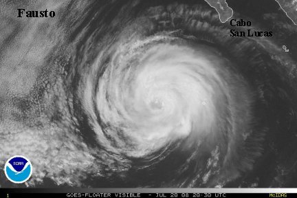
Sunday Evening Update
Hurricane Fausto is still at 85 mph and is continues to move northwest.
Satellite imagery from the last several hours show that Fausto's eyewall has expanded. Upper level divergence also is impressive with the noted cirrus banding. We agree with NHC that Fausto may be a bit stronger than the offical maximum sustained winds of 85 mph.

Fausto will move over colder water within 12-24 hours and should start the decrease in strength. Fausto will only effect Mexico with its sea swell.

TropicalWeather.net's Tropical Pic
Image
Rich Johnson
Twitter: https://twitter.com/richjohnsonwx
Certified Broadcast Meteorologist - Hurricane Expert
User avatar
Tropical Inspector
Site Admin
Site Admin
Posts: 3694
Joined: Tue Feb 20, 2007 2:28 pm
Antispam: no
Location: Under a palm tree
Contact:

Post by Tropical Inspector »

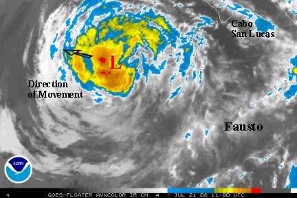
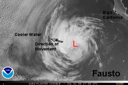
Monday Morning Update
NHC increased Fausto's winds up to 100 mph per the 5 am edt advisory.
Certainly, at that time Fausto looked very impressive. Fausto is now degenerating very rapidly. The eastern half of the eye wall has collapsed and top sustained winds are probably 80 mph. Winds take some time to "spin down" and don't lower quite a fast, even though 100 to 80 seems like a big jump.

Fausto is a little over 400 miles southwest of Cabo San Lucas. The swell will continue to decrease as Fausto continues to weaken as it moves over colder water and farther away.

TropicalWeather.net's Tropical Pic
Image
Rich Johnson
Twitter: https://twitter.com/richjohnsonwx
Certified Broadcast Meteorologist - Hurricane Expert
User avatar
Tropical Inspector
Site Admin
Site Admin
Posts: 3694
Joined: Tue Feb 20, 2007 2:28 pm
Antispam: no
Location: Under a palm tree
Contact:

Post by Tropical Inspector »

Monday Afternoon Update
NHC dropped Fausto on their last advisory to agree with our previous assessment.....top sustained winds 80 mph. Since then cloud tops have warmed and the eye is totally clouded over. It looks like the top winds are now closer to minimal hurricane strength or just below.....70-75 mph. Look for Fausto to drop to tropical storm strength soon and gradually weaken over the next few days over colder water.

TropicalWeather.net's Tropical Pic
Image
Rich Johnson
Twitter: https://twitter.com/richjohnsonwx
Certified Broadcast Meteorologist - Hurricane Expert
User avatar
Tropical Inspector
Site Admin
Site Admin
Posts: 3694
Joined: Tue Feb 20, 2007 2:28 pm
Antispam: no
Location: Under a palm tree
Contact:

Post by Tropical Inspector »

Monday Evening Update
Fausto's top sustained winds were taken down to 70 mph on the last NHC advisory. Fausto will continue to weaken as it heads west well away fom Mexico toward cooler water. Fausto should become a tropical depression probably by sometime tomorrow.

Since Fausto is no threat to land and should be dissipating soon, this will be the last update.
Rich Johnson
Twitter: https://twitter.com/richjohnsonwx
Certified Broadcast Meteorologist - Hurricane Expert
Post Reply

Return to “2008 Eastern / Central Pacific Hurricane Season Archives”

Who is online

Users browsing this forum: No registered users and 1 guest