|
|
Hurricane pictures / summaries 2001
Satellite images provided by NOAA / NASA / MODIS. Hurricane tracks courtesy of the National Hurricane Center.
 Click pictures for close up view Click pictures for close up view
|
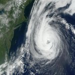
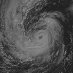
Hurricane Erin
September 11, 2001
Hurricane Erin formed off of the coast of Africa and moved westward. As it moved northwest of the Leeward Islands wind shear
caused Erin to degenerate into a weak low. Shortly after, Erin restrengthened and moved northward bypassing Bermuda to the east. At its
strongest, Hurricane Erin reached category 3 strength. It brushed by Newfoundland as it just dropped below hurricane force. No damage was reported
with Hurricane Erin.
|
|
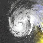
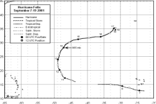
Hurricane Felix
September 14, 2001
Hurricane Felix was a category 3 hurricane that did not effect land and caused no damage. It formed well off of the coast of African
turned northward and was heading toward the general direction of the Azores. It stalled and weakened before reaching the islands.
|
|
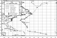
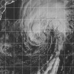
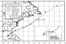
Hurricane Gabrielle
September 17, 2001
Hurricane Gabrielle developed in the southeast Gulf and made landfall as a strong tropical storm near Venice, Florida. Gabrielle dumped a
swath of 4-7 inches of rain with with to 12" in Lake and Volusia counties. As Gabrielle moved off of Florida's east coast it strengthened into a
hurricane as it bypassed Bermuda. It eventually effected Newfoundland with more than 6" of rain.
|
|
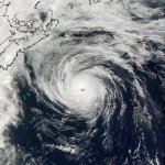
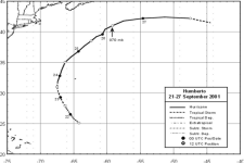
Hurricane Humberto
September 26, 2001
Hurricane Humberto started from a trough of low pressure to the southwest of Hurricane Gabrielle several hundred miles north-northeast of
Puerto Rico. It became a hurricane as it continued northward and passed roughly about 100 miles west of Bermuda. It reached category 2
status and curved northeast across the shipping lanes of the north Atlantic where it dissipated.
|
|
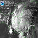
Hurricane Iris
October 8, 2001
Hurricane Iris began as a tropical depression east of the Windward Islands. It steadily strengthened after passing the islands and reached hurricane status south of
Haiti. It passed just south of Jamaica and continued westward. It made landfall in southern Belize near Monkey River Town as a category 4 hurricane with 145 mph top
sustained winds. The Hurricane Hunters discovered three seperate eyewalls with Hurricane Iris, which is very unusual.
|
|
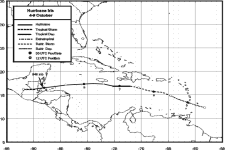
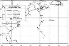
Hurricane Karen
October 14, 2001
Hurricane Karen developed on a stalled cold front south of Bermuda. As a subtropical storm, it brought significant damage to
Bermuda. Up the 23,000 were without power. Winds gusted up to 100 mph at the airport and one of the three cruiseships anchored in Bermuda's
harbor reported a gust to 118 mph by Nordic Empress. This was probably a convective burst in a strong downdraft. Karen briefly strengthened into
a hurricane. It weaked into a tropical storm as it affected Newfoundland where it helped the drought by bringing about 1.5" of rain.
|
|
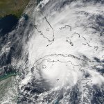
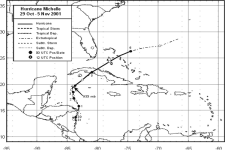
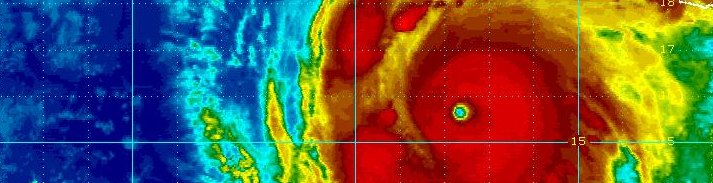
Hurricane Michelle
November 4, 2001
Hurricane Michelle was the strongest hurricane to hit Cuba since Hurricane Fox in 1952. Michelle formed off of the coast of Nicaragua and moved north. It rapidly
intensified before hitting Cuba and became a category 4 hurricance with top sustained winds of 140 mph. Gusts of 130 mph were measured at Cayo Largo and Jaguey Grande in Cuba.
Nassau reported a gust to 102 mph. Severe flooding occured in Nicaragua, Jamaica and Honduras. Western and central Cuba had tens of thousands of homes destroyed with hundreds of
thousands sustaining damage.
|
|
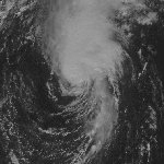
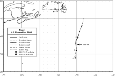
Hurricane Noel
November 5, 2001
Hurricane Noel was a lonely system. It formed well east-northeast of Bermuda, moved north and briefly became a hurricane. There was
no damage reported from Noel.
|
|
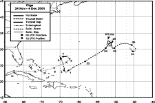
Hurricane Olga
November 27, 2001
Hurricane Olga formed several hundred miles east-southeast of Bermuda. It took an unusual course, including a tight loop then moving
southwest before moving north again and weakening. The only damage was to a lone ship in the open Atlantic.
|
Hurricane pictures and summaries main page.
|
|
|
)
)
)
)
)
)
)
)
)
)
)
)
)
)
)
)
)
)